
Ad Pontem
Ad Pontem: The Roman Service Station That Put Newark on the Map (Literally)
Long before Newark-on-Trent was known for its castle, Civil War sieges, or enviable tea rooms, there was a strategic Roman pit stop nearby called Ad Pontem—Latin for “by the bridge.” And no, it wasn’t a charming riverside café, but rather a bustling Roman settlement that served as a vital waypoint on one of Britain’s most important roads: the Fosse Way.
Stretching from Exeter to Lincoln, the Fosse Way was the Roman Empire’s answer to a high-speed motorway—minus the traffic cones. Ad Pontem sat snugly along this route, near a crossing of the River Trent, making it the perfect place for Roman soldiers, traders, and sandal-clad wanderers to rest, resupply, and maybe complain about the weather.
The earliest known reference to Ad Pontem appears in the Antonine Itinerary, a 2nd-century Roman road map for the weary imperial traveller. In Iter VI—“the route from London to Lincoln”—Ad Pontem is listed as being 7 Roman miles from both Margidunum (modern-day Castle Hill near Bingham – more on that soon) and Crococolana (modern-day Brough)
This prime location suggests it may have hosted a mansio (an official Roman inn) or a mutatio (a horse-changing station)
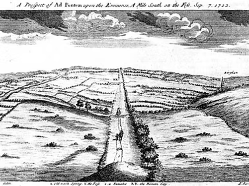
Ad Pontem wasn’t just a glorified lay-by. It featured a fortlet—a small military encampment with ramparts and a double-ditch defensive system. Measuring about 1¼ acres, this fort was discovered in the 1950s via aerial photography and later excavated in the 1960s. It likely dates back to the early Claudian period (mid-1st century AD), and even revealed traces of Iron Age occupation beneath its Roman ramparts
Nearby, a larger polygonal enclosure—spanning over 5 acres—was crossed by the Fosse Way itself. This was no sleepy outpost; it was a well-planned, defended settlement with a clear eye on both military and commercial traffic
According to the most comprehensive report by Trent and Peak Archaeology (1992), the site east of the Fosse Way developed in four distinct phases
-
Late Iron Age: Two superimposed buildings beneath the fort rampart, associated with Iron Age pottery.
-
1st Century AD: A military complex with ramparts, double ditches, and a polygonal enclosure.
-
3rd Century: A rectilinear enclosure with three ditches, one of which was filled in during this period.
-
Later Roman Period: A larger enclosure with a 2.5m-thick stone wall and two outer ditches (later merged into one).
A metalled track crossed the site from east to west, linking directly to the Fosse Way. Stone buildings—some dating to the 2nd century—were found adjacent to the road, suggesting a mix of military and civilian use
.
The name “Ad Pontem” likely refers to a series of bridges over the River Trent near Fiskerton, where an ancient trackway intersected the Fosse Way. This trackway, possibly predating the Romans, connected the area to the villa at Denton and continued north toward the territory of the Brigantes, one of Britain’s largest tribes
Archaeological finds from the site include:
-
Coins
-
Pottery
-
Glassware
-
Iron tools
-
Painted wall plaster
These artefacts suggest that Ad Pontem wasn’t just a military post—it was a lively civilian settlement that thrived from the late 1st century to at least the 4th century AD
Though Ad Pontem is technically closer to the village of East Stoke, its legacy is deeply entwined with Newark-on-Trent. Many of the artefacts unearthed from the site are housed in regional museums, including those in Newark.
Sadly, not much is visible to the naked eye today —unless you’re an archaeologist with a drone and a dream. The site is now a Scheduled Monument, protected for its historical significance. But beneath the fields of East Stoke and Brough lie the remnants of a once-thriving Roman hub that helped connect Britannia to the wider empire